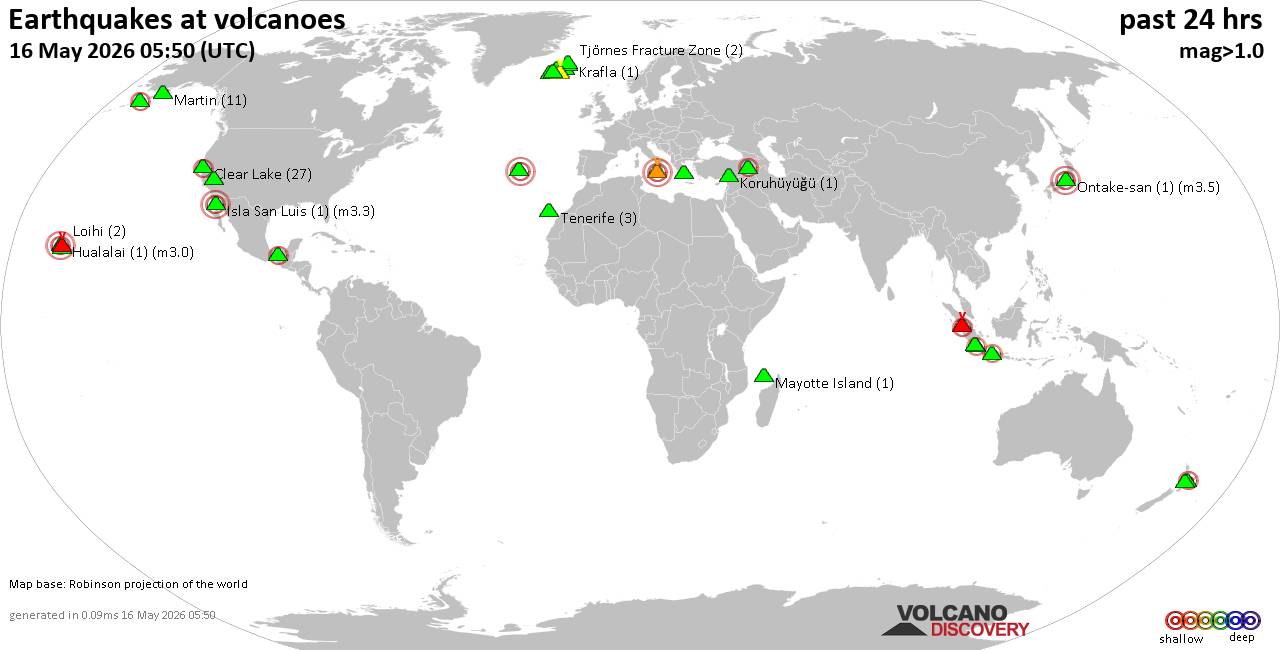
World map showing volcanoes with shallow (less than 50 km) earthquakes within 20 km radius during the past 24 hours on 16 May 2026 Number in brackets indicate nr of quakes.Quakes detected near: Akyarlar (1 quake mag 1.6), Brennisteinsfjöll (2 quakes between mag 1.1-1.3), Churchill (1 quake mag 1.0), Clear Lake (28 quakes between mag 0.2-1.4), Coso (3 quakes between mag 1.6-2.4), Don Joao de Castro Bank (1 quake mag 3.0)El Chichón (1 quake mag 2.2), Eldey (6 quakes between mag 0.6-1.8), Gede-Pangrango (1 quake mag 2.1), Hualalai (1 quake mag 3.0), Irazu (1 quake mag 1.4), Izumbwe-Mpoli (1 quake mag 3.0), Katla (7 quakes between mag 0.0-2.2), Kilauea (4 quakes between mag 1.3-1.9), Koruhüyüğü (1 quake mag 1.8), Krafla…

Worldwide earthquakes above magnitude 3 during the past 24 hours on 16 May 2026Summary: 3 quakes 5.0+, 40 quakes 4.0+, 148 quakes 3.0+, 283 quakes 2.0+ (474 total)This report is being updated every hour.Magnitude 5+: 3 earthquakesMagnitude 4+: 40 earthquakesMagnitude 3+: 148 earthquakesMagnitude 2+: 283 earthquakesNo quakes of magnitude 6 or higher10 largest earthquakes in the world (past 24 hours)#1: Mag 5.2 Central Mid-Atlantic RidgeFriday, May 15, 2026, at 01:27 pm (GMT -1) - #2: Mag 5.0 Province of Sultan Kudarat, Autonomous Region in Muslim Mindanao, 184 km south of Cagayan de Oro, PhilippinesSaturday, May 16, 2026, at 07:25 pm (Manila time) - #3: Mag 5.0 Kermadec Islands RegionSaturday, May 16, 2026, at 06:48 pm (GMT +12) - #4: Mag…

Explosive activity continues. Volcanic Ash Advisory Center (VAAC) Tokyo warned about a volcanic ash plume that rose up to estimated 13000 ft (4000 m) altitude or flight level 130 and is moving at 20 kts in SE direction.The full report is as follows:FVFE01 at 12:00 UTC, 16/05/26 from RJTDVA ADVISORYDTG: 20260516/1200ZVAAC: TOKYOVOLCANO: BEZYMIANNY 300250PSN: N5558 E16036AREA: RUSSIASOURCE ELEV: 2882M AMSLADVISORY NR: 2026/11INFO SOURCE: HIMAWARI-9ERUPTION DETAILS: VA EMISSIONS CONTINUINGOBS VA DTG: 16/1120ZOBS VA CLD: SFC/FL130 N5558 E16034 - N5608 E16040 - N5424 E16403 - N5359 E16306 MOV SE 20KTFCST VA CLD +6 HR: 16/1720Z SFC/FL130 N5334 E16733 - N5259 E16618 - N5509 E16108 - N5558 E16036FCST VA CLD +12 HR: 16/2320Z SFC/FL140 N5155 E17028 - N5438 E16102 - N5558 E16028 -…
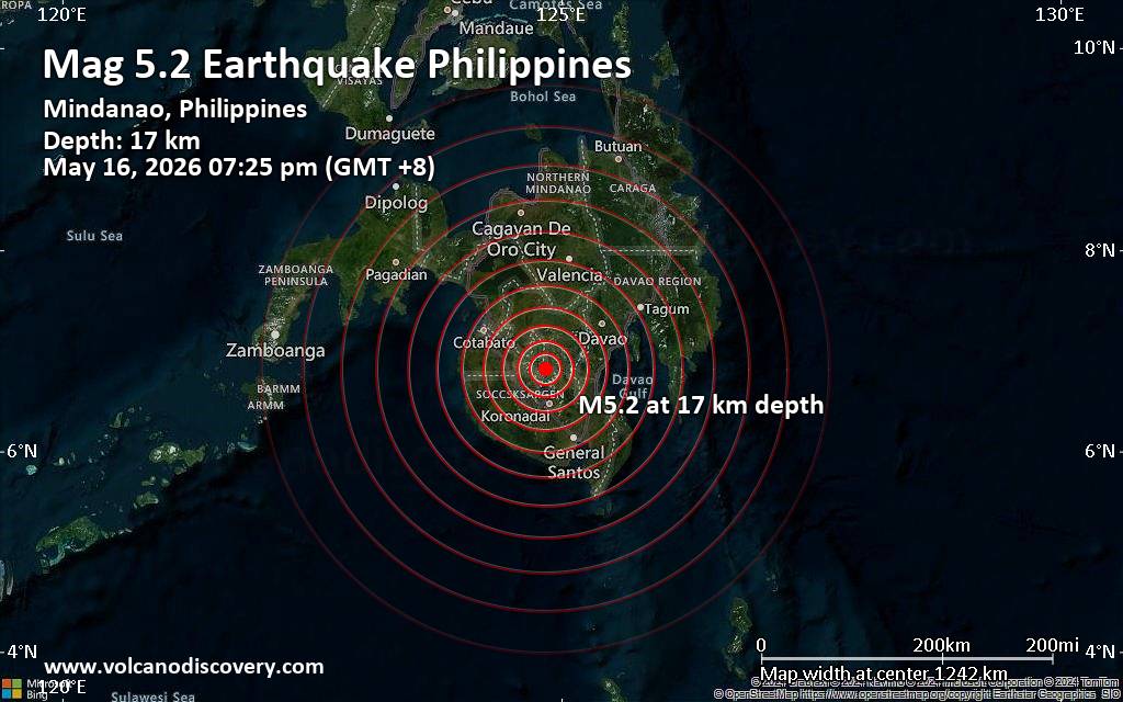
Just 7 minutes ago, a 5.2-magnitude earthquake struck near Koronadal, South Cotabato, Soccsksargen, Philippines. The tremor was recorded early evening on Saturday, May 16th, 2026, at 7:25 pm local time, at a shallow depth of 17. km below the surface.The event was filed by the European-Mediterranean Seismological Centre (EMSC), the first seismological agency to report it.Our monitoring service identified a second report from Indonesia's Meteorology, Climatology, and Geophysical Agency which listed the quake at magnitude 5.1. A third agency, the German Research Centre for Geosciences (GFZ), reported the same quake at magnitude 5.2.Based on the preliminary seismic data, the quake was probably felt by many people in the area of the epicenter. It should not have caused significant damage, other…
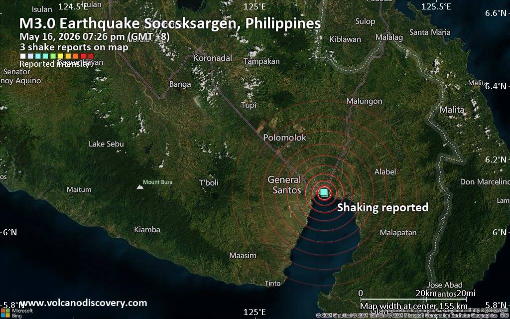
Unconfirmed quake or seismic-like event reported: 2.2 km east of General Santos, Philippines, 1 minute agoWe are receiving unverified early reports of ground shaking possibly caused by seismic activity in or near General Santos, Soccsksargen, Philippines on 16 May 2026 (GMT) at approximately 11:26 GMT.There are no details yet on the magnitude or depth of this possible quake. If confirmed, we can expect more accurate data to emerge in the next few minutes. The location, magnitude and time mentioned are indicative, based on our best-fit seismic model. They are temporary until our AllQuakes monitoring service receives more exact scientific data from a national or international seismological agency. Check back here shortly and stay safe.Earthquake data: Date & time: May 16,…
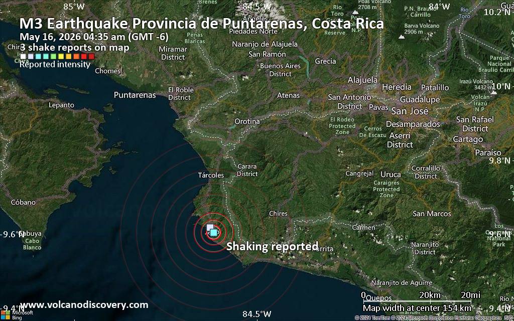
Unconfirmed quake or seismic-like event reported: 1.6 km southeast of Jaco, Provincia de Puntarenas, Costa Rica, 5 minutes agoWe are receiving unverified early reports of ground shaking possibly caused by seismic activity in or near Jaco, Puntarenas Province, Costa Rica on 16 May 2026 (GMT) at approximately 10:35 GMT.There are no details yet on the magnitude or depth of this possible quake. If confirmed, we can expect more accurate data to emerge in the next few minutes. The location, magnitude and time mentioned are indicative, based on our best-fit seismic model. They are temporary until our AllQuakes monitoring service receives more exact scientific data from a national or international seismological agency. Check back here shortly and stay safe.Earthquake data: Date…
A pause at Kilauea headlined a busy day, while Indonesia’s eruptive tempo stayed high. Semeru registered 53 explosions with signals of pyroclastic density currents, and Dukono tallied 74 blasts that lofted plumes to 3.4 km. Compared with yesterday, alerts shifted: Kilauea dropped to Advisory/Yellow, Kanlaon decreased to Level 1, while Taal rose to Level 2.United StatesKilauea’s eruption paused; Kilauea was lowered to Advisory with Aviation Yellow after Episode 47 ended following about nine hours of lava fountaining. In the Aleutians, Great Sitkin stayed at Watch/Aviation Orange with a slow, ongoing eruption. Unrest continued at Kupreanof and Shishaldin (both Advisory/Aviation Yellow).IndonesiaExplosive activity was notable: Semeru produced 53 explosions with seismic signals of pyroclastic density currents and a flowage event, while Dukono…
The Observatorio Vulcanológico y Sismológico de Costa Rica - Universidad Nacional (OVSICORI-UNA) issued a report for Irazú between 7 May 2026 (local) and 15 May 2026 (local). The alert level remained at "Level 1 - Calm" (on a 0–4 level scale). Source: Observatorio Vulcanológico y Sismológico de Costa Rica - Universidad Nacional (OVSICORI-UNA)Current Alerts:Observatory alert level: "Level 1 - Calm" (on a 0–4 level scale)Aviation Alert Level: unavailable or not collectedAdapted from: Smithsonian / USGS Daily Volcanic Activity Report for May 15, 2026
The Center for Volcanology and Geological Hazard/Pusat Vulkanologi dan Mitigasi Bencana Geologi (CVGHM/PVMBG) issued a report for Tangkuban Parahu on 15 May 2026 (local). The alert level remained at "Level 1 - Normal" (on a 4-level scale). Source: Center for Volcanology and Geological Hazard/Pusat Vulkanologi dan Mitigasi Bencana Geologi (CVGHM/PVMBG)Current Alerts:Observatory alert level: "Level 1 - Normal" (on a 4-level scale)Aviation Alert Level: unavailable or not collectedAdapted from: Smithsonian / USGS Daily Volcanic Activity Report for May 15, 2026
The Center for Volcanology and Geological Hazard/Pusat Vulkanologi dan Mitigasi Bencana Geologi (CVGHM/PVMBG) reported that unrest continued at Telong, Bur ni on 15 May 2026 (local). The alert level remained at "Level 2 - Alert" (on a 4-level scale). Source: Center for Volcanology and Geological Hazard/Pusat Vulkanologi dan Mitigasi Bencana Geologi (CVGHM/PVMBG)Current Alerts:Observatory alert level: "Level 2 - Alert" (on a 4-level scale)Aviation Alert Level: unavailable or not collectedAdapted from: Smithsonian / USGS Daily Volcanic Activity Report for May 15, 2026
The Center for Volcanology and Geological Hazard/Pusat Vulkanologi dan Mitigasi Bencana Geologi (CVGHM/PVMBG) reported that unrest continued at Dempo on 15 May 2026 (local). The alert level remained at "Level 2 - Alert" (on a 4-level scale). Source: Center for Volcanology and Geological Hazard/Pusat Vulkanologi dan Mitigasi Bencana Geologi (CVGHM/PVMBG)Current Alerts:Observatory alert level: "Level 2 - Alert" (on a 4-level scale)Aviation Alert Level: unavailable or not collectedAdapted from: Smithsonian / USGS Daily Volcanic Activity Report for May 15, 2026
The Center for Volcanology and Geological Hazard/Pusat Vulkanologi dan Mitigasi Bencana Geologi (CVGHM/PVMBG) reported that unrest continued at Gamalama on 15 May 2026 (local). The alert level remained at "Level 2 - Alert" (on a 4-level scale). Source: Center for Volcanology and Geological Hazard/Pusat Vulkanologi dan Mitigasi Bencana Geologi (CVGHM/PVMBG)Current Alerts:Observatory alert level: "Level 2 - Alert" (on a 4-level scale)Aviation Alert Level: unavailable or not collectedAdapted from: Smithsonian / USGS Daily Volcanic Activity Report for May 15, 2026
The Center for Volcanology and Geological Hazard/Pusat Vulkanologi dan Mitigasi Bencana Geologi (CVGHM/PVMBG) reported that unrest continued at Karangetang on 15 May 2026 (local). The alert level remained at "Level 2 - Alert" (on a 4-level scale). Source: Center for Volcanology and Geological Hazard/Pusat Vulkanologi dan Mitigasi Bencana Geologi (CVGHM/PVMBG)Current Alerts:Observatory alert level: "Level 2 - Alert" (on a 4-level scale)Aviation Alert Level: unavailable or not collectedAdapted from: Smithsonian / USGS Daily Volcanic Activity Report for May 15, 2026
The Center for Volcanology and Geological Hazard/Pusat Vulkanologi dan Mitigasi Bencana Geologi (CVGHM/PVMBG) reported that unrest continued at Kerinci on 15 May 2026 (local). Gas and vapor plume(s) rose to a maximum of 200 m (656 ft) above the vent. Seismically detected flowage events were recorded 1 times. The alert level remained at "Level 2 - Alert" (on a 4-level scale). Activity also included: seismically detected flowage event(s). Source: Center for Volcanology and Geological Hazard/Pusat Vulkanologi dan Mitigasi Bencana Geologi (CVGHM/PVMBG)Current Alerts:Observatory alert level: "Level 2 - Alert" (on a 4-level scale)Aviation Alert Level: unavailable or not collectedAdapted from: Smithsonian / USGS Daily Volcanic Activity Report for May 15, 2026
The Center for Volcanology and Geological Hazard/Pusat Vulkanologi dan Mitigasi Bencana Geologi (CVGHM/PVMBG) reported that unrest continued at Krakatau on 15 May 2026 (local). Gas and vapor plume(s) rose to a maximum of 5 m (16 ft) above the vent. The alert level remained at "Level 2 - Alert" (on a 4-level scale). Source: Center for Volcanology and Geological Hazard/Pusat Vulkanologi dan Mitigasi Bencana Geologi (CVGHM/PVMBG)Current Alerts:Observatory alert level: "Level 2 - Alert" (on a 4-level scale)Aviation Alert Level: unavailable or not collectedAdapted from: Smithsonian / USGS Daily Volcanic Activity Report for May 15, 2026
The United States Geological Survey - Alaska Volcano Observatory (USGS-AVO) reported that unrest continued at Kupreanof between 14 May 2026 (local) and 15 May 2026 (local). The alert level remained at "Advisory" (level 2 on a 4-level scale). The aviation alert level remained at "Yellow" (level 2 on a 4-level scale). Source: United States Geological Survey - Alaska Volcano Observatory (USGS-AVO)Current Alerts:Observatory alert level: "Advisory" (level 2 on a 4-level scale)Aviation Alert Level: "Yellow" (level 2 on a 4-level scale)Adapted from: Smithsonian / USGS Daily Volcanic Activity Report for May 15, 2026
RSS Error: A feed could not be found at `https://rss.app/feeds/2uaX4LJv39eZr1pA.xml`; the status code is `402` and content-type is `text/plain; charset=utf-8`
RSS Error: A feed could not be found at `https://rss.app/feeds/KD843mj8YEDbLDRX.xml`; the status code is `402` and content-type is `text/plain; charset=utf-8`