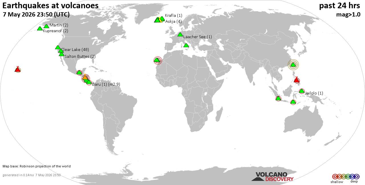
World map showing volcanoes with shallow (less than 50 km) earthquakes within 20 km radius during the past 24 hours on 7 May 2026 Number in brackets indicate nr of quakes.Quakes detected near: Banahaw (1 quake mag 1.5), Bardarbunga (8 quakes between mag 0.0-1.7), Brennisteinsfjöll (3 quakes between mag 0.0-1.9),…

Worldwide earthquakes above magnitude 3 during the past 24 hours on 7 May 2026Summary: 6 quakes 5.0+, 39 quakes 4.0+, 148 quakes 3.0+, 349 quakes 2.0+ (542 total)This report is being updated every hour.Magnitude 5+: 6 earthquakesMagnitude 4+: 39 earthquakesMagnitude 3+: 148 earthquakesMagnitude 2+: 349 earthquakesNo quakes of magnitude 6…
Frequent explosive activity in Indonesia and Guatemala stood out today, while Hawaii's Kilauea slipped into a pause. Popocatepetl's ground alert shifted to Orange, and Italy's Stromboli showed both Strombolian bursts and effusive lava.United StatesGreat Sitkin (Watch / Aviation ORANGE) kept slow lava effusion inside the summit crater with weak steaming;…
The Center for Volcanology and Geological Hazard/Pusat Vulkanologi dan Mitigasi Bencana Geologi (CVGHM/PVMBG) reported that the eruption continued at Dukono on 6 May 2026 (local). There were 82 explosions reported, with plumes rising to a maximum of 1,500 m (4,921 ft) above the vent. The alert level remained at "Level…
The Instituto Nacional de Sismología, Vulcanología, Meteorología e Hidrología (INSIVUMEH) reported that the eruption continued at Fuego between 5 May 2026 (local) and 6 May 2026 (local). There were explosions reported, occurring at a rate of up to 13 per hour, with plumes rising to a maximum of 937 m…
The Observatorio Argentino de Vigilancia Volcánica (OAVV) reported that the eruption continued at Great Sitkin between 5 May 2026 (local) and 6 May 2026 (local). A webcam image showed weak steaming from the active lava flow. Lava continued to slowly erupt in the summit crater. Rockfalls generated by the growing…
The Center for Volcanology and Geological Hazard/Pusat Vulkanologi dan Mitigasi Bencana Geologi (CVGHM/PVMBG) reported that the eruption continued at Ibu on 6 May 2026 (local). Gas and vapor plume(s) rose to a maximum of 200 m (656 ft) above the vent. There were 126 explosions reported, with plumes rising to…
The United States Geological Survey - Hawaiian Volcano Observatory (USGS-HVO) reported that there was a pause in eruptive activity at Kilauea between 5 May 2026 (local) and 6 May 2026 (local). Glow was observed overnight from both the north and south vents. The lava flows on the crater floor remained…
The Philippine Institute of Volcanology and Seismology (PHIVOLCS) reported that the eruption continued at Kanlaon on 6 May 2026 (local). A total of 7 ash emission events, each lasting between 7 and 70 minutes, were recorded. Ash plumes rose 600 m above the vent and drifted SW and W. Tremor…
The Center for Volcanology and Geological Hazard/Pusat Vulkanologi dan Mitigasi Bencana Geologi (CVGHM/PVMBG) reported that the eruption continued at Lewotobi (Laki-Laki) on 6 May 2026 (local). Gas and vapor plume(s) rose to a maximum of 100 m (328 ft) above the vent. There was 1 seismically detected rockfall. Low-frequency (LF)…
The Center for Volcanology and Geological Hazard/Pusat Vulkanologi dan Mitigasi Bencana Geologi (CVGHM/PVMBG) reported that the eruption continued at Lewotolok on 6 May 2026 (local). Gas and vapor plume(s) rose to a maximum of 100 m (328 ft) above the vent. There were 50 seismically detected rockfalls. The alert level…
The Center for Volcanology and Geological Hazard/Pusat Vulkanologi dan Mitigasi Bencana Geologi (CVGHM/PVMBG) reported that the eruption continued at Marapi on 6 May 2026 (local). There were 2 seismically detected explosions reported. The alert level remained at "Level 2 - Alert" (on a 4-level scale). Source: Center for Volcanology and…
The Philippine Institute of Volcanology and Seismology (PHIVOLCS) reported that the eruption continued at Mayon on 6 May 2026 (local). Lava effusion continued from the summit crater. As of 6 May, lava flow lengths remained at 3.8 km in the Basud Gully (E flank), 3.2 km in the Bonga Gully…
The Center for Volcanology and Geological Hazard/Pusat Vulkanologi dan Mitigasi Bencana Geologi (CVGHM/PVMBG) reported that the eruption continued at Merapi on 6 May 2026 (local). There were 4 hot rockfalls, traveling up to 2,000 m. There were 121 seismically detected rockfalls. The alert level remained at "Level 3 - Standby"…
The Centro Nacional de Prevención de Desastres (CENAPRED) reported that the eruption continued at Popocatépetl between 5 May 2026 (local) and 6 May 2026 (local). Ash, gas, and vapor plume(s) were reported. At 2018 on 5 May, a M1.5 volcano-tectonic (VT) earthquake was recorded. The alert level remained at "Orange"…
The Observatorio Vulcanológico y Sismológico de Costa Rica - Universidad Nacional (OVSICORI-UNA) reported that the eruption continued at Poás between 5 May 2026 (local) and 6 May 2026 (local). Plume(s) were reported. The alert level remained at "Level 2 - Warning" (on a 0–4 level scale). The aviation alert level…
The Instituto Geofísico-Escuela Politécnica Nacional (IG-EPN) reported that the eruption continued at Reventador between 5 May 2026 (local) and 6 May 2026 (local). There were 98 seismically detected explosions reported. Ash and gas plume(s) rose to a maximum of 1,000 m (3,281 ft) above the vent. There were incandescent rockfalls,…
The Centro Vulcanológico Nacional del Instituto Geofísico del Perú (CENVUL-IGP) reported that the eruption continued at Sabancaya between 5 May 2026 (local) and 6 May 2026 (local). Ash, gas, and vapor plume(s) rose to a maximum of 1,200 m (3,937 ft) above the vent. A total of 10 earthquakes related…
RSS Error: A feed could not be found at `https://rss.app/feeds/2uaX4LJv39eZr1pA.xml`; the status code is `402` and content-type is `text/plain; charset=utf-8`
RSS Error: A feed could not be found at `https://rss.app/feeds/KD843mj8YEDbLDRX.xml`; the status code is `402` and content-type is `text/plain; charset=utf-8`