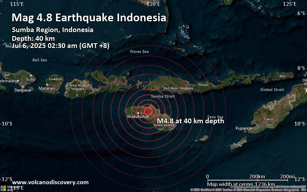
Just 6 minutes ago, a 4.8-magnitude earthquake struck near Waingapu, Kabupaten Sumba Timur, East Nusa Tenggara, Indonesia. The tremor was recorded early morning on Sunday, July 6th, 2025, at 2:30 am local time, at a moderately shallow depth of 40. km below the surface.The event was filed by Indonesia's Meteorology, Climatology, and Geophysical Agency, the first seismological agency to report it.Based on the preliminary seismic data, the quake should not have caused any significant damage, but was probably felt by many people as light vibration in the area of the epicenter. Weak shaking might have been felt in Waingapu (pop. 35,900) located 51 km from the epicenter, and Tambolaka (pop. 35,800) 64 km away.Other towns or cities near the epicenter…
Worldwide earthquakes above magnitude 3 during the past 24 hours on 5 Jul 2025Summary: 2 quakes 5.0+, 27 quakes 4.0+, 213 quakes 3.0+, 360 quakes 2.0+ (602 total)This report is being updated every hour.Magnitude 5+: 2 earthquakesMagnitude 4+: 27 earthquakesMagnitude 3+: 213 earthquakesMagnitude 2+: 360 earthquakesNo quakes of magnitude 6 or higher10 largest earthquakes in the world (past 24 hours)#1: Mag 5.4 East China Sea, Kagoshima-ken, 54 km southwest of Suwanose-jima Island, JapanSaturday, Jul 5, 2025, at 06:29 am (GMT +9) - #2: Mag 5.1 131 km south of Antofagasta, Provincia de Antofagasta, Region de Antofagasta, ChileSaturday, Jul 5, 2025, at 10:47 am (Santiago time) - #3: Mag 4.9 Morobe Province, 171 km north of Port Moresby, Papua New GuineaSaturday,…
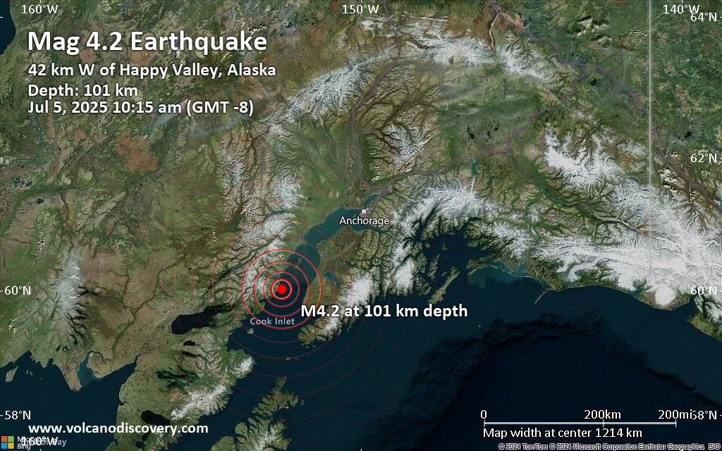
An intermediate magnitude 4.2 earthquake was reported in the morning near Anchor Point, Kenai Peninsula, Alaska, USA.According to the United States Geological Survey, the quake hit on Saturday, July 5th, 2025, at 10:15 am local time at an intermediate depth of 63 miles. The strength of the earthquake may have been tempered by its relative great depth below the surface, which makes it feel weaker in absolute terms. The exact magnitude, epicenter, and depth of the quake might be revised within the next few hours or minutes as seismologists review data and refine their calculations, or as other agencies issue their report.Our monitoring service identified a second report from The Incorporated Research Institutions for Seismology (IRIS) which listed the quake…
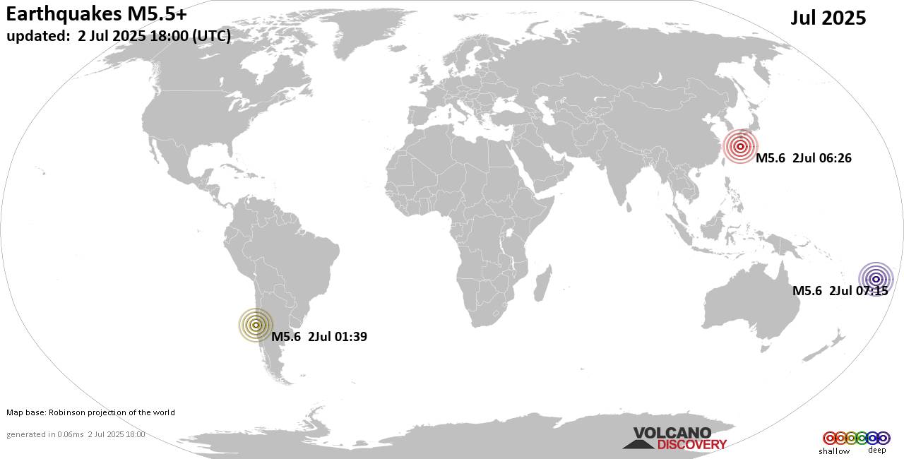
Worldwide earthquakes above magnitude 5.5 during July 2025Summary: 1 quake 6.0+, 30 quakes 5.0+, 206 quakes 4.0+, 1125 quakes 3.0+, 1845 quakes 2.0+ (3207 total)This report is being updated every day.Magnitude 9+: noneMagnitude 8+: noneMagnitude 7+: noneMagnitude 6+: 1 earthquakeMagnitude 5+: 30 earthquakesMagnitude 4+: 206 earthquakesMagnitude 3+: 1125 earthquakesMagnitude 2+: 1845 earthquakesNo quakes of magnitude 7 or higherList of 10 largest earthquakes in the world during July 2025:#1: Mag 6.0 South Atlantic Ocean, 304 km southeast of Isla Phillips Island, Region de Magallanes y Antartica Chilena, ChileFriday, Jul 4, 2025, at 12:47 pm (GMT -3) - #2: Mag 5.6 East China Sea, Okinawa, 5.1 km west of Iejima Island, JapanThursday, Jul 3, 2025, at 02:31 pm (GMT +9) - #3:…
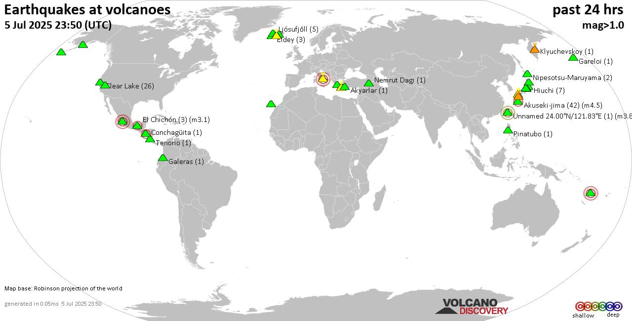
World map showing volcanoes with shallow (less than 50 km) earthquakes within 20 km radius during the past 24 hours on 5 Jul 2025 Number in brackets indicate nr of quakes.Quakes detected near: Akuseki-jima (45 quakes between mag 1.8-4.7), Akyarlar (4 quakes between mag 1.1-1.7), Aso (3 quakes between mag 0.4-1.9), Campi Flegrei (Phlegrean Fields) (13 quakes between mag 0.1-3.0), Clear Lake (27 quakes between mag 0.2-1.6), Conchagüita (1 quake mag 2.4)El Chichón (3 quakes between mag 2.6-3.1), Eldey (3 quakes between mag 0.7-1.2), Galeras (1 quake mag 1.6), Hekla (1 quake mag 1.3), Kamen (1 quake mag 1.8), Katla (9 quakes between mag 0.3-1.3), Kilauea (1 quake mag 1.9), Klyuchevskoy (4 quakes between mag 1.1-1.7), Kolumbo (8 quakes between…

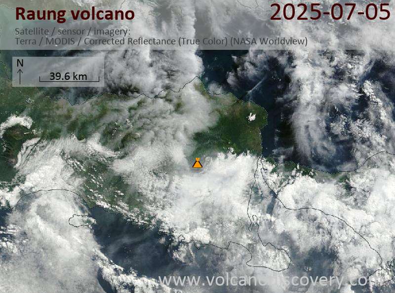
Satellite image of Raung volcano on 5 Jul 2025

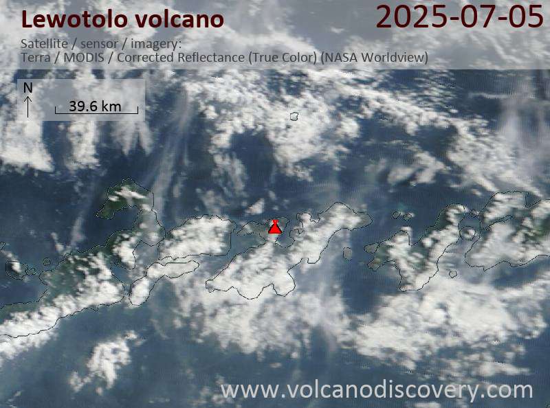
Satellite image of Lewotolo volcano on 5 Jul 2025

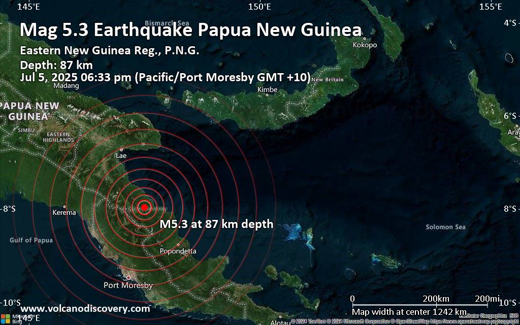
The European-Mediterranean Seismological Centre (EMSC) reported a magnitude 5.3 quake in Papua New Guinea near Kokoda, Sohe District, Northern Province, only 18 minutes ago. The earthquake hit early evening on Saturday, July 5th, 2025, at 6:33 pm local time at an intermediate depth of 87. km. The exact magnitude, epicenter, and depth of the quake might be revised within the next few hours or minutes as seismologists review data and refine their calculations, or as other agencies issue their report.A second report was later issued by the citizen-seismograph network of RaspberryShake, which listed it as a magnitude 5.3 earthquake as well. A third agency, the German Research Centre for Geosciences (GFZ), reported the same quake at magnitude 5.3.Based on the…
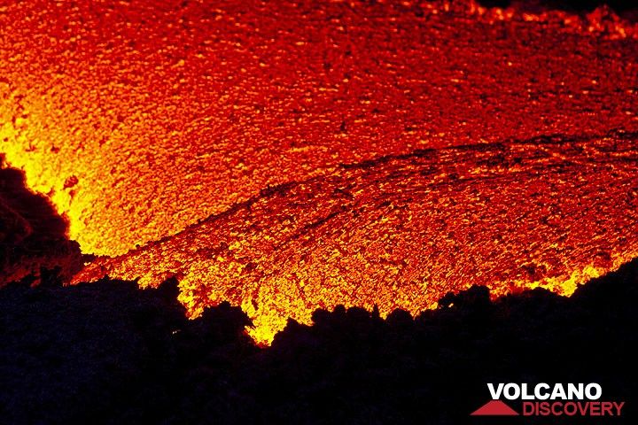
Lava flow close-up (Pacaya volcano, Guatemala)
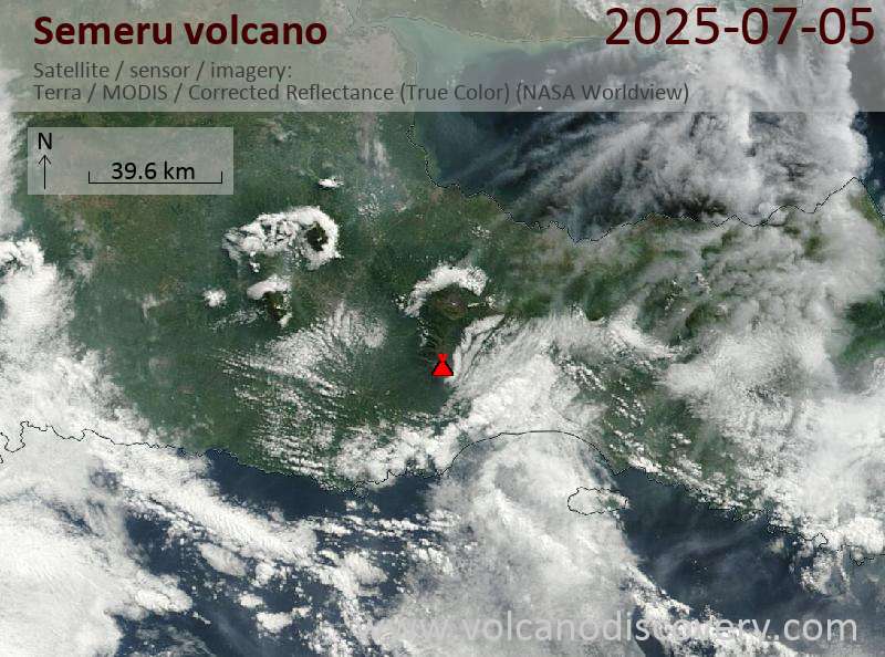
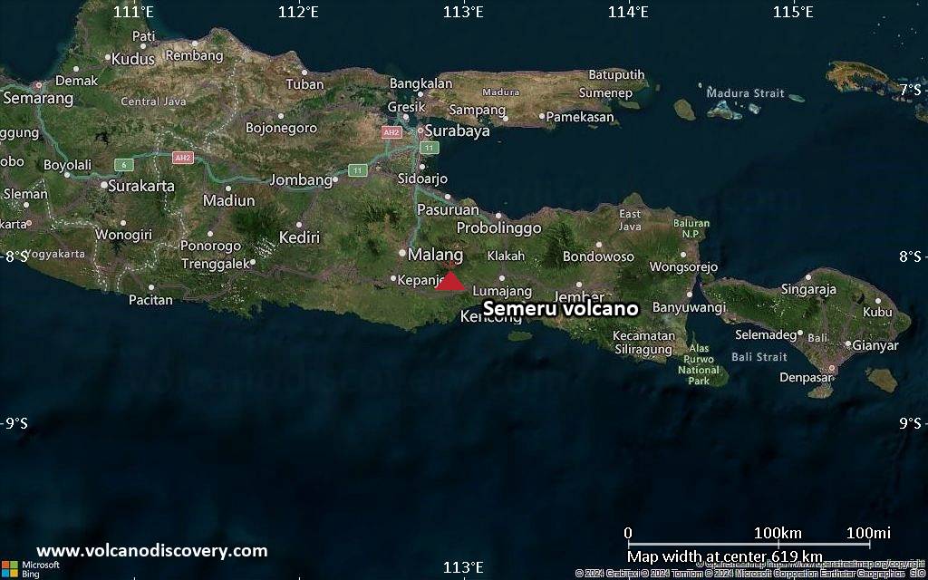
Satellite image of Semeru volcano on 5 Jul 2025
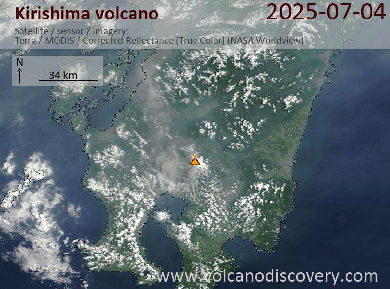
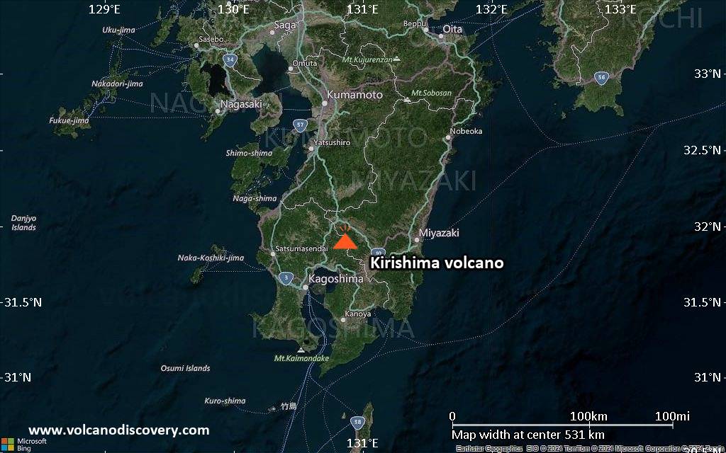
Satellite image of Kirishima volcano on 5 Jul 2025
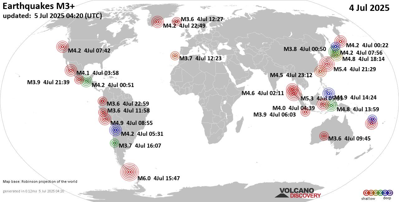
Worldwide earthquakes above magnitude 3 during the past 24 hours on 5 Jul 2025Summary: 1 quake 6.0+, 2 quakes 5.0+, 42 quakes 4.0+, 230 quakes 3.0+, 373 quakes 2.0+ (648 total)Magnitude 6+: 1 earthquakeMagnitude 5+: 2 earthquakesMagnitude 4+: 42 earthquakesMagnitude 3+: 230 earthquakesMagnitude 2+: 373 earthquakesNo quakes of magnitude 7 or higher10 largest earthquakes in the world (4 Jul 2025)#1: Mag 6.0 258 km Al S De Puerto WilliamsFriday, Jul 4, 2025, at 12:47 pm (GMT -3) - #2: Mag 5.4 104 km NNW of Tatsugō, JapanSaturday, Jul 5, 2025, at 06:29 am (GMT +9) - #3: Mag 5.3 Indonesia: Nicobar Islands, India RegionFriday, Jul 4, 2025, at 12:33 pm (Pontianak time) - #4: Mag 4.9 62 km SSE of…
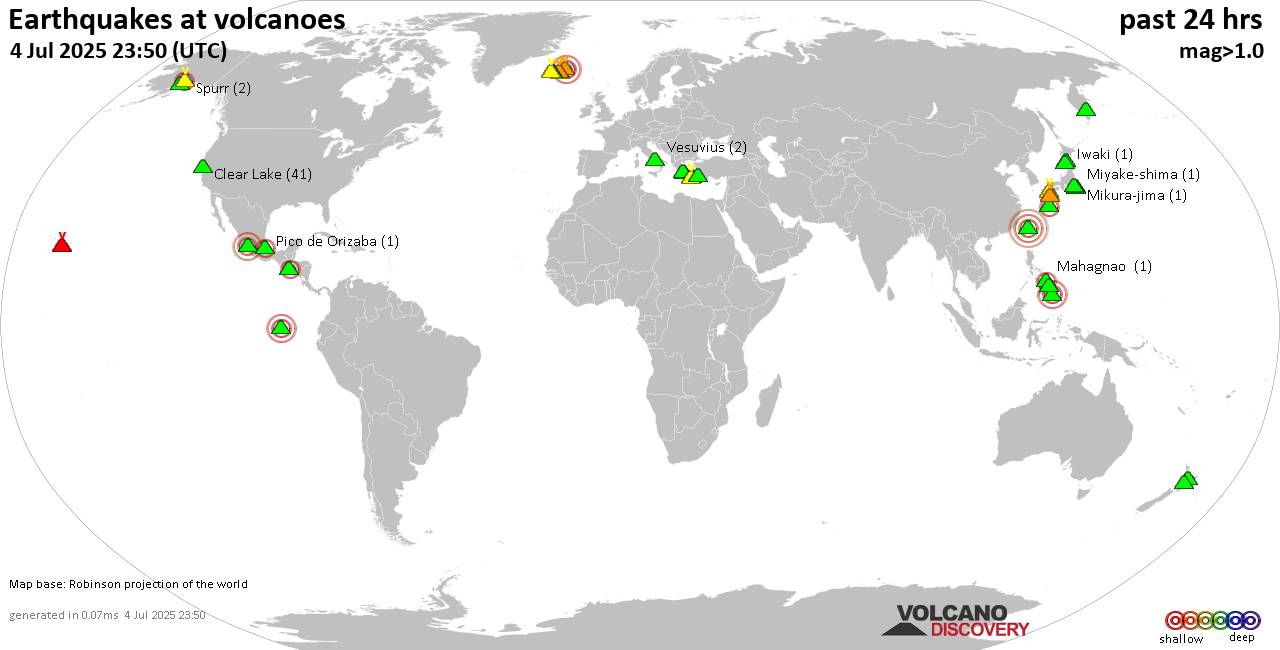
World map showing volcanoes with shallow (less than 50 km) earthquakes within 20 km radius during the past 24 hours on 4 Jul 2025 Number in brackets indicate nr of quakes.Quakes detected near: Akuseki-jima (52 quakes between mag 1.9-4.7), Akyarlar (3 quakes between mag 1.1-1.7), Aso (2 quakes between mag 0.1-1.4), Bardarbunga (3 quakes between mag 0.7-3.6), Brennisteinsfjöll (2 quakes between mag 0.5-1.0), Clear Lake (41 quakes between mag 0.2-2.4)Coatepeque (1 quake mag 2.7), Hekla (1 quake mag 1.3), Iwaki (1 quake mag 1.1), Katla (2 quakes between mag 0.6-2.1), Kilauea (1 quake mag 1.9), Kirishima (3 quakes between mag 0.2-1.1), Kitkhoysky (1 quake mag 1.6), Kolumbo (4 quakes between mag 1.2-1.9), Leonard Range (1 quake mag 3.0), Mahagnao (1…
Map of today's active volcanoesShiveluch (Kamchatka): Explosive activity continues. Volcanic Ash Advisory Center (VAAC) Tokyo warned about a volcanic ash plume that rose up to estimated 15000 ft (4600 m) altitude or flight level 150 and is moving at 5 kts in W direction.The full report is as follows: POSS ERUPTION OBS AT 20250704/1650Z FL150 EXTD W OBS VA DTG:04/1730Z to 15000 ft (4600 m)Kirishima (Kyushu): Explosive activity continues. Volcanic Ash Advisory Center (VAAC) Tokyo warned about a volcanic ash plume that rose up to estimated 17000 ft (5200 m) altitude or flight level 170 and is moving at 15 kts in SW direction.The full report is as follows: POSS VA EMISSIONS CONTINUING OBS VA DTG:04/1720Z to 17000 ft (5200…
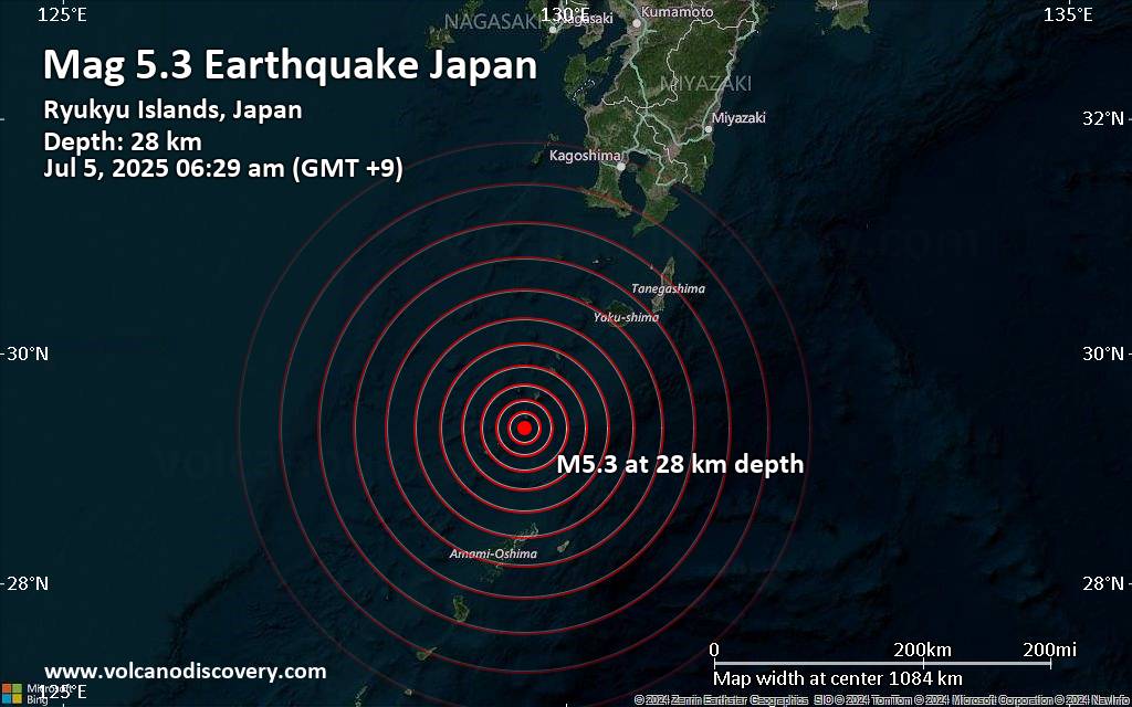
An earthquake of magnitude 5.3 occurred only 9 minutes ago 111 km north of Naze, Japan, the European-Mediterranean Seismological Centre (EMSC) reported.The quake hit at a shallow depth of 28. km beneath the epicenter near Naze, Amami Shi, Kagoshima-ken, Japan, early morning on Saturday, July 5th, 2025, at 6:29 am local time. The exact magnitude, epicenter, and depth of the quake might be revised within the next few hours or minutes as seismologists review data and refine their calculations, or as other agencies issue their report.A second report was later issued by France's Réseau National de Surveillance Sismique (RéNaSS), which listed it as a magnitude 5.3 earthquake as well. Other agencies reporting the same quake include the citizen-seismograph network of…

A very shallow magnitude 2.5 earthquake was reported in the morning near Walnut Creek, Contra Costa County, California, USA.According to the United States Geological Survey, the quake hit on Friday, July 4th, 2025, at 11:16 am local time at a very shallow depth of 5.1 miles. Shallow earthquakes are felt more strongly than deeper ones as they are closer to the surface. The exact magnitude, epicenter, and depth of the quake might be revised within the next few hours or minutes as seismologists review data and refine their calculations, or as other agencies issue their report.Our monitoring service identified a second report from The Incorporated Research Institutions for Seismology (IRIS) which listed the quake at magnitude 2.5 as well. A…
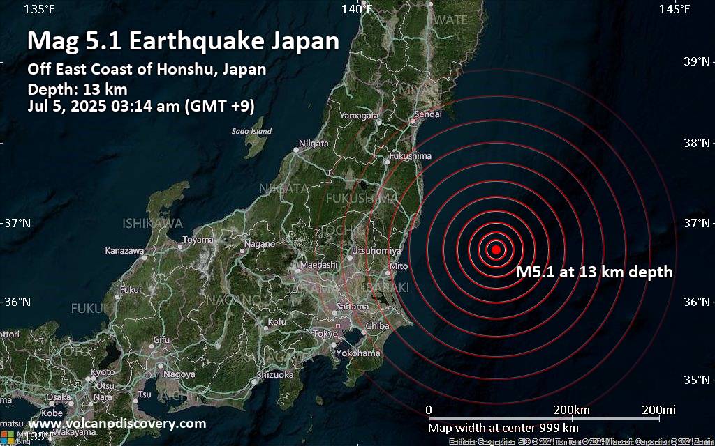
Japan was shaken near Iwaki, Iwaki-shi, Fukushima, by an earthquake of magnitude 5.1 only 12 minutes ago, the European-Mediterranean Seismological Centre (EMSC) reported.The quake hit at a shallow depth of 13. km beneath the epicenter near Iwaki, Iwaki-shi, Fukushima, Japan, early morning on Saturday, July 5th, 2025, at 3:14 am local time. Shallow earthquakes are felt more strongly than deeper ones as they are closer to the surface. The exact magnitude, epicenter, and depth of the quake might be revised within the next few hours or minutes as seismologists review data and refine their calculations, or as other agencies issue their report.Our monitoring service identified a second report from the German Research Centre for Geosciences (GFZ) which listed the quake…

Some impressions from our walking and study tour to Lesbos in May 2025.
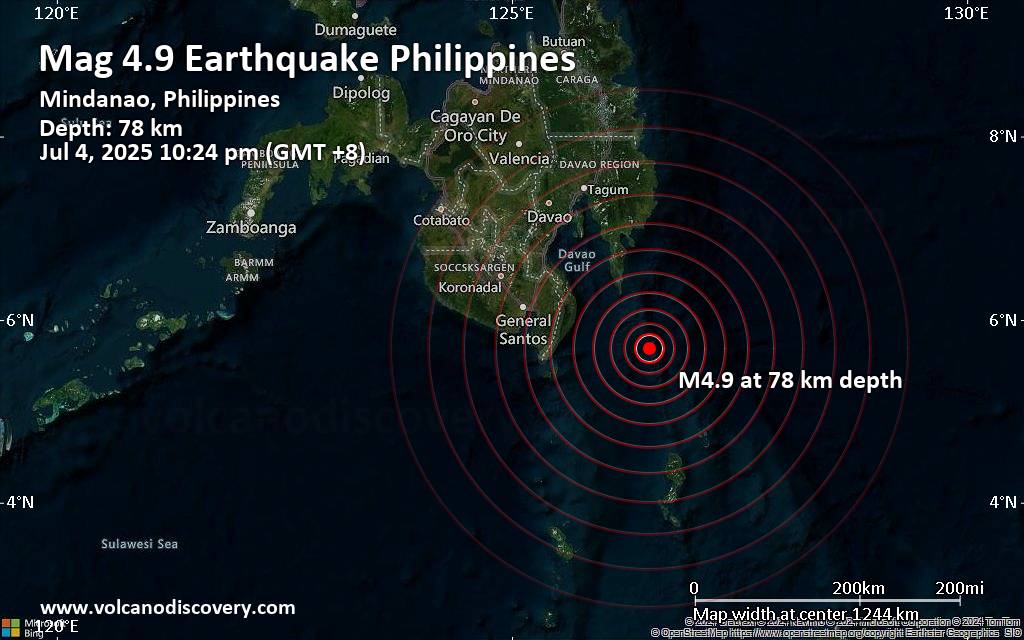
An intermediate magnitude 4.9 earthquake was reported late at night near Pondaguitan, Davao Oriental, Davao, Philippines.According to Indonesia's Meteorology, Climatology, and Geophysical Agency, the quake hit on Friday, July 4th, 2025, at 10:24 pm local time at an intermediate depth of 78. km. The exact magnitude, epicenter, and depth of the quake might be revised within the next few hours or minutes as seismologists review data and refine their calculations, or as other agencies issue their report.Our monitoring service identified a second report from the citizen-seismograph network of RaspberryShake which listed the quake at magnitude 5.0. Other agencies reporting the same quake include the European-Mediterranean Seismological Centre (EMSC) at magnitude 5.0, and the German Research Centre for Geosciences (GFZ) at…
Your account has been suspended. Please update your subscription plan at rss.app. - (2uaX4LJv39eZr1pA)
Your account has been suspended. Please update your subscription plan at rss.app. - (KD843mj8YEDbLDRX)